The latest in my collection of space books is a reproduction of the work of amateur astronomer Hugh Percival Wilkins, who used a 300inch telescope to sketch the lunar surface from his back garden, using the sketches to create some of the most detailed maps of the lunar surface at the time.
His first edition was released to critical acclaim in 1946, but he continued to update and revise the map until the third edition in 1953. His map was considered the the best available for astronomers and was even bought by NASA to be used as reference for the Apollo missions and for use with the first clear photographs returned by American and Russian probes. Although his maps were criticised for being overcrowded and complex, they are amazingly accurate.
An example of two sections of the map showing the area around the crater Copernicus.
Wilkins also sketched and drew sections of landscape and individual craters by hand from his observations. The final map was a huge 100 inch diameter diagram, comprised of 25 individual sections, which when laid out covered the entire disk of the visible surface. After his death, just 9 years before the moon landing, the map was acquired by the Royal Observatory museum in Greenwich.
Lunar Atlas representation of Kepler Crater
Lunar Orbiter Photograph of Kepler
Wilkins sketch of the shadow on Kepler Crater
Comparison of the area around Alphonsus Crater and Wilkins observational sketches of the dark area within Alphonsus, with notes regarding additional features for which he was often criticised.
 |
Sea of Tranquility as it appears in the book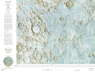 | | Lunar Astronautical Chart of the area around Julius Caesar crater and Sea of Tranquility |
|
I order to check the veracity of Wilkins maps, I found the area showing part of the Sea of Tranquility, where the first moon landing took place and referenced it against the Lunar Atlas and a shot taken by the Lunar Orbiter missions.
 |
| Wilkins map inverted |
 |
| Consolidated Lunar Atlas Photograph |
It took a little time to identify the area in Wilkins book, but eventually I realised that the relevant map area was upside down!
Despite the orientation of the map in the book, overlaying it onto accurate astronomical charts show a remarkable level of accuracy for a hand drawn map.
Some of the features in Wilkins map do appear slightly out of position, but the map does not take into account the curvature of the lunar globe, as seen in the last photograph, so some distortion and some aberration due to the lens of the telescope must be allowed for.


